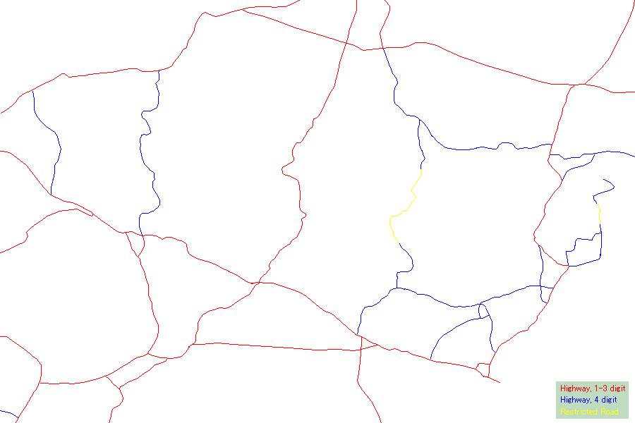
| Crossing Roads (from left to right): 3222, 2090/3077, 304, 3462, 348, 3308 | |||
 |
|||
| Crossing Roads (from left to right): 3222, 2090/3077, 304, 3462, 348, 3308 | |||
|
|||
|
R 3222 The Series 1501 (1st ed., 1967) only partially shows this road (5km from Kaeng Khoi on R 2, 15km from Ban Na on R 33). |
| Other than the deduction that the road must have been constructed after 1967, its historical details are unknown to the author. |
|
R 2090/3077 The Series 1501 (1st ed., 1967) only shows upper half of this road, and describes it as R 121. |
|||||
|
The construction of this road started from R 2, after the designation of Khao Yai National Park in 1962. It was completed sometime after 1967, but the precise year is unknown to the author. The road cuts through the Khao Yai National Park, and there are toll gates both at the northern entrance to the National Park (on R 2090) and at the southern entrance (on R 3077).
|
|
R 304 The Series 1501 (1st ed., 1967) shows this road, and notes as "Construction 1966." |
|||
The construction of this road started in 1966 and was completed in 1969.
|
|
R 3462 (restricted) The Series 1501 (3rd ed., 1974) doesn't show this road (upper part from Khon Buri). The Series 1501 (4th ed., 1980) doesn't show this road (lower part from Sa Kaeo). |
|
This road cuts through the Thap Lan National Park (in the north) and Pang Sida National Park (in the south). It is deduced that the road was constructed after 1980, but the precise year is unknown to the author. The core section of this road, cutting through the Dangrek Mountain Range, is restricted and it may very well be impassable with its degenerated road condition. On the southern side, if you enter Pang Sida National Park (with an entrance fee), you can follow R 3462 for some 20km into the mountain range (mostly dirt road) until you reach a barricade. On the northern side, R 3462 brings you to a Thap Lan National Park checkpoint, beyond which the road turns into dirt. Unlike National Park toll gates, where you can easily pass as long as you pay the entrance fee, you need a good reason to pass through this checkpoint. |
|
R 348 The Series 1501 (3rd ed., 1974) only partially shows this road, and describes it as R 2118 (near Nang Rong) and R 3068 (near Ta Phraya). |
|||
|
The road construction started in 1975 and was completed in 1979. The core section of this road which crosses the mountain range (succession of steep, twisty corners) is only about 2.5km.
|
|
R 3308 (restricted) The Series 1501 (3rd ed., 1976) doesn't show this road, but it shows a "cart track" along this route. |
|
The historical details of this road are unknown to the author. It is assumed that this road was constructed not before the completion of R 348. The core section of this road which crosses the mountain range is restricted with barricades at both ends, though the road is paved all the way and it poses no physical difficulties as in the case of R 3462. Passage may be granted upon request at the Border Patrol Police station adjacent to each barricade, but this is rather an exception than a rule. Even local residents living near the restricted section must make a detour on R 348. The road post in the restricted section reads R 3308, but its covered with white paint, probably meaning cancellation as a national highway under the jurisdiction of the Department of Highways. Thus, technically, R 3308 consists of two discontinuous sections. A road sign at the north end of R 3308 reads [Khok Pek 48, Ta Phraya 53]. This may be an indication that, at some time in the past, this road was open to the public. Or else, it may be another case of administrative inconsistency between different government agencies, and the road was never open to the public. |
| Protected Area | |
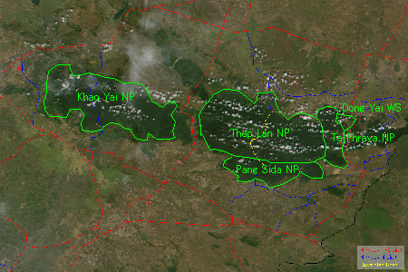 |
Khao Yai National Park (1962) . 2168 km2
Dong Yai Wildlife Sanctuary (1996) . ? km2Thap Lan National Park (1981) . 2241 km2 Pang Sida National Park (1982) . 844 km2 Ta Phraya National Park (?, after 2001) . 594 km2 Boundary lines of protected areas on the left map is estimated from various sources, and may not be accurate. The forest area not designated as a National Park or Wildlife Sanctuary is still mostly designated as a "National Forest Reserve." All national parks listed above now have toll gates, collecting 200B from foreigners. |
