|
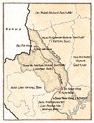
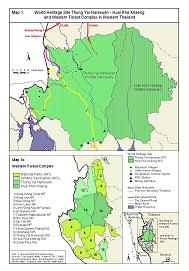
Road Network in the Thung Yai Naresuan Wildlife Sanctuary
Supplementary Information to Three Pagodas by Christian Goodden Information/Correction Solicited |
||
 |  |  |
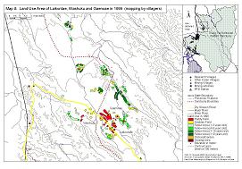 | 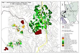 | 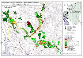 |
Maps 2 - 6 are downloaded from http://www.sefut.uni-freiburg.de/buergineng.htm |
||
|
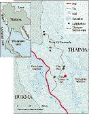
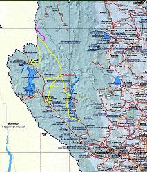
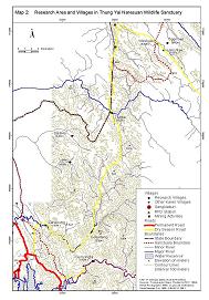
Red Line: Highway R1090 practically ends at the W.S. checkpoint/guardhouse/barrier, but the road stretches further 75km into the W.S.
R1288 ends at the border village Boeng Kloeng. Both R1090 and R1288 pass through Umpang Wildlife Sanctuary, thus W.S. checkpoints. Tourists on a motor vehicle may not be allowed to pass, depending on various factors and circumstances. However, compared to the Thung Yai Naresuan W.S., the Umpang W.S. is more open to the public, as the following article suggests:
http://www.thaiparks123.com/en/othersubpark_wildlife.cfm?detailid=2 From Umphang district-where a permit to enter the wildlife sanctuary can be obtained from the Umphang Tourism Business and Nature Preservation Group-you have to drive further to Thilorsu along a 27-km jungle track that is passable only during the dry months. http://scoop.bangkokpost.co.th/bkkpost/2000/bp2000_feb/bp20000221/210200_Outlook07.html |
||
|
Yellow Line: Dirt Track The Thung Yai/Naresuan W.S. is highly protective against visitors. Tourists on a motor vehicle, without prior permission, are most likely turned back at some checkpoint.
http://www.wcmc.org.uk/protected_areas/data/wh/thungyai.html Two dry season roads have been built through the sanctuary to service the mining operations. The first was built over 30 years ago and runs from the southern border of Thung Yai north through to the "Big Field" from which Thung Yai gets its name, then curves west before terminating near Jagae. The second road, only about 10 years old, enters Thung Yai near Sangklaburi town, and runs past the villages of Sanepong; Gohsaduang, then north past Tilaipa and Jagae before connecting with the first road. Together they form a horseshoe-shaped circuit through the sanctuary. http://www.princeton.edu/~yyodin/chang/forest2.html Pictorial |
||
|
Purple Line: Military Dirt Track built in 2000 Bangkok Post Articles |
||
|
Feasibility of driving a 4WD/motorcycle from Umpang to Kanchanaburi Apart from difficulties in acquiring a permission to drive through the Thung Yai Naresuan W.S., there doesn't seem to be a vehicle track between Boeng Kloeng and Ban Suriya (upper end of the military road). (approx. 10km?) As to driving along the Burmese border to Sangklaburi, there is another obstacle. A section of the dirt track between Phu Jue Mine and Ti Lai Pa crosses the Burmese border several times and, under the current political situation in Burma, this section is highly dangerous. |
||
|
More Articles Critics question merits of sanctuary HQ scheme / July 29, 1996 Where the big wheels go / January 9, 1997 |
||
Localities |
|||
Boeng Kloeng (Beung Keung, Perng Klerng, etc)
http://www.chakkham.ac.th/thailandday/TAK.htm |
|||
 Lae Tong Ku (Le Tong Ku, Leh Tong Ku, etc) Lae Tong Ku (Le Tong Ku, Leh Tong Ku, etc)Christian describes as "Lae Tong Ku was on the southernmost edge of Um Pang district." Following articles suggest that there is now a 4WD track between Boeng Kloeng and Lae Tong Ku.
They believe that only moral, peaceful acts in the present life can carry one's soul to be born in the next Buddha's era. Drinking and quarreling is an absolute no-no in the village. So are stealing and killing. Most of them are vegetarians. These millenarians might not be able to cite what the Five Precepts are, but they are actually living the essence of Buddhist teachings, which the modern Thais have discarded, preserving only the outer forms. My hope for the Leh Tong Ku has turned out to be a wishful thinking. My colleague, after returning from the jungle community, told me that the border police patrols have shaven the Leh Tong Ku's heads, forcing them to wear school uniforms, and imposing our brand of Buddhism by putting a Buddha image in their shrine. http://search.bangkokpost.co.th/bkkpost/1997/january1997/bp970123/2301_news28.html The Le Tong Ku Fair is held annually at the Le Tong Ku village in Umphang District of Tak Province. Living in remote areas, groups of Karens firmly believe in the village holy men and hold elephant tusks as sacred talismans. On the fullmoon day of the 12th Lunar month (coinciding with early November), a fire tribute is made to earn merits for late ancestors. http://www.mfa.go.th/internet/document/h_sec8fin.pdf 4WD Treks The winding road from Mae Sot to Umphang is one of the most challenging mountain routes. The 164 km stretch takes 4-5 hours to negotiate. From Umphang, you can continue on the road to the beautiful Sepla Waterfall passing through the dolomite mountain of Doi Hua Mod and the Karen village of Palata. Another route leads to the majestic Ti Lo Su waterfall and on to the Karen settlements of Ban Tipoji and Bueng Faed and the "Karen rishi" village of Le Tong Ku, whose spiritual leader is a Karen ethnic hermit. This route is passable from November-April only. Jungle Treks Most who come to Mae Sot are determined to see the spectacular Ti Lo Su Waterfall. Tour operators usually offer mountainbiking, elephant-back rides, or rafting for part of the long trek, but most of it is done on foot. The route consists of several sections: Tha Sai-Ti Lo So on foot or elephant back, Ti Lo Re-Palata on elephant back and on foot, Tipoji-Bueng Faed-Le Tong Ku on foot. You have to be reasonably fit to attempt the trek, but itfs worth it once you get to the waterfall, which ranks in the top ten most beautiful in the world. http://www.tat.or.th/do/tak.htm Further south from Peung Kleung the going gets tough. The unique Lae Thong Ku village, with another beautiful waterfall, is only four hours walk in theory (there is no road) but is often off limits due to fighting between the KNU and the Burmese Army. Note : Guides from Umphang may take you there, but under no circumstances should this trip be attempted alone. http://www.chakkham.ac.th/thailandday/TAK.htm Travels between Tipoji-Bueng Faed must be authorized by the Royal Forestry Department. Toursts wishing to visit Le Tong Ku village must receive permission from the Border Patrol Police's 347 Platoon (tel:66-55/561-008). Only small groups travelling on foot are allowed to visit the area. http://www.thaifood.com.au/aboutthai/thaitravel/dec2.htm Curious article in French / with web translation 1.Trekking from Umpang to Sangklaburi 2.The Shaman-God of the Karen |
|||
|
Sanepong Popular destination for trek tours from Sangkhlaburi.
http://karenpeople.org/buerginreiner2001.pdf |
|||
Lead Mines
|
|||
|
Klity (Kliti, etc) The Klity Mine has been polluting the Klity Creek over the years, and a dozen Karen villages (eg. Ban Klity Larng) along this creek have been severely affected. |
