| SmartMap Thailand | Series 1501 |
 |
 |
|
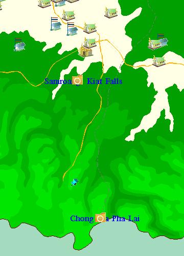
Light Blue Pin: 14o 24' 05" N . 104o 27' 43" E The distance between the end of R2236 and Chong Pra Pha Lai is about 6km. |
Red Line: Highways overlaid from Smartmap Thailand Blue Line: R2236 supplemented to reach the army camp Yellow Line: Narrow, steep downhill dirt path (end unknown) Red Ellipse: Approximate position of the Phra Palai Pass (overlaid from Smartmap Thailand) |
Comments
Series 1501 suggests an easily accessible route to Phra Palai Pass, mostly cutting through plains. It is natural to assume that, historically, this easy route was used for log transport through this pass. Series 1501 doesn't show any road along this route. Perhaps, they dragged logs to the river and floated them down.
The economic prospect of R2236 is not apparent. It climbs up a mountain to the army camp (highest point in the vicinity), then turns into a narrow, steep downhill dirt path. The dirt path probably reaches the stratigically important Phra Palai Pass, but inconvenient for log transport unless they widen and flatten the path.
Quotes from Global Witness
The report has omitted Phra Palai checkpoint which lies to the east of Chongsa-Ngam. Global Witness investigations revealed the presence of a large road heading due south to a small Thai base, approximately 6 km from the border. This road is approximately the size of a three lane highway, and could easily accommodate log trucks.
In December 1996 and January 1997 the road to the Thai/Cambodia border at Prapalai was being graded by heavy equipment, creating a three lane laterite road of excellent quality.
